December 2025 Monthly Summary
December 2025 began with an active weather pattern, followed by extended quiet stretches and fewer storms. The month ended with unusually warm conditions and rain over the holidays.
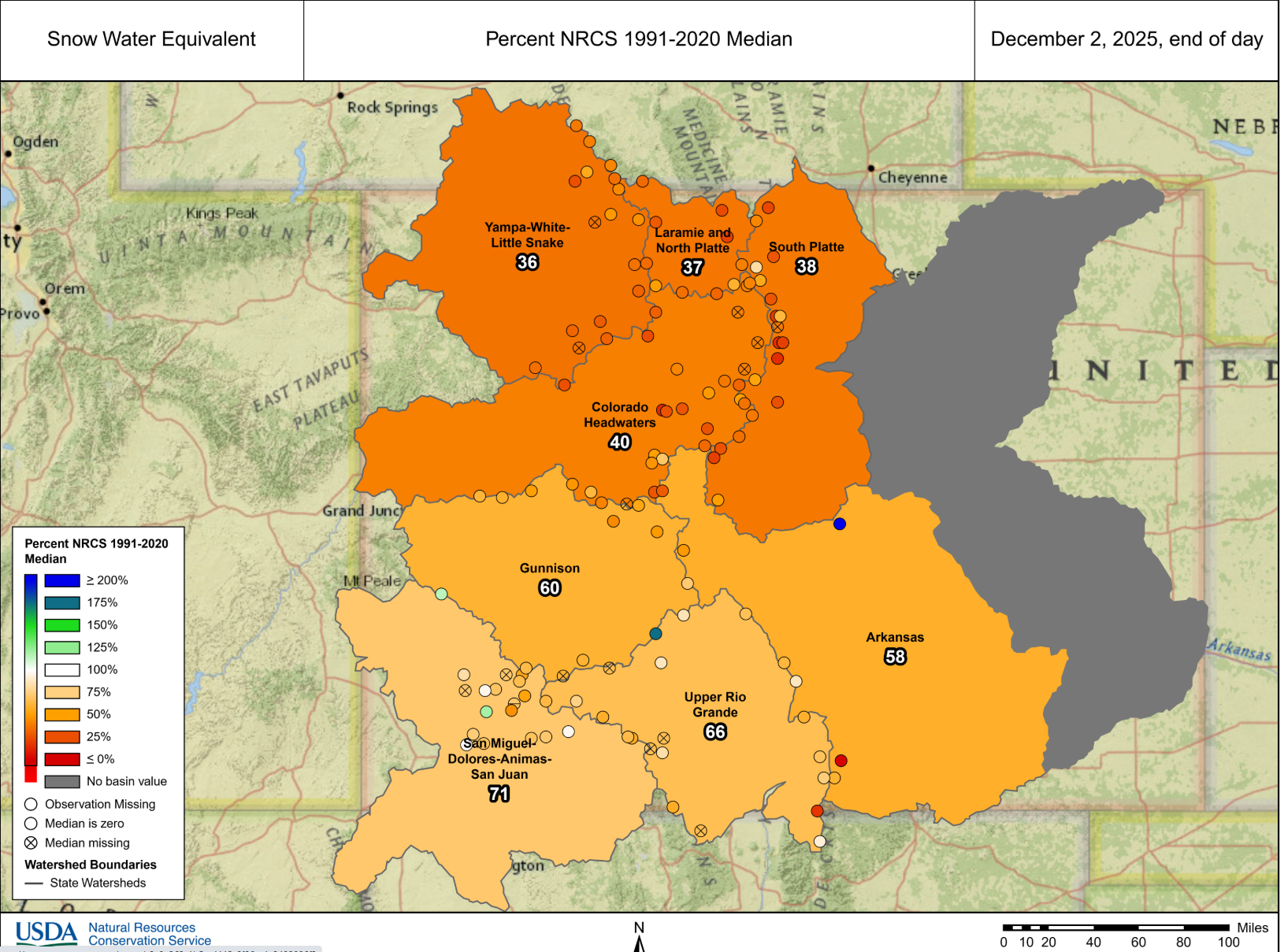
Figure: Colorado snowpack conditions as of December 2, 2025. Snow water equivalent (SWE) was well below average across much of the state, particularly in the Northern and Central Mountains, contributing to a thin and fragile early-season snowpack.
Early December storms delivered the most impactful snowfall of the month. Strong winds during this period built thin slabs over November’s weak layers, producing a cycle of mostly small avalanches around December 6 that tapered off into the second week of the month.
After December 9, snowfall became scarce statewide as warm, dry weather dominated much of the month. Avalanche activity dropped off as the snowpack stabilized during this quiet period, but the snowpack weakened across many mountain ranges, particularly on shaded aspects and areas with a thinner snowpack. Avalanche activity ramped back up as a historically warm storm arrived on December 25. Rain fell up to 11,000 feet in many areas of the state, an unprecedented event in many locations. Another small cycle of avalanches ran between December 25 and 28 in the western Central Mountains, with additional avalanches reported in the San Juan Mountains.
Statewide avalanche activity (December 2025):
- 347 avalanches recorded across the state
- 41 avalanche size D2 & D2.5
- 303 avalanches size D1 & D1.5
- 53 human-triggered avalanches
- 6 people caught, none injured
Northern Mountains
The Northern Mountains experienced its most active period during the first week of December. A storm on December 4 favored the east side of the Front Range and Park Range, followed by a strong atmospheric river from December 5–7 that delivered 1–2 feet of snow across much of the region and up to 3 feet in the Park Range. Strong northwest winds built slabs of drifted snow at all elevations, including below treeline.
Avalanche activity peaked between December 3–9, with roughly 40 avalanches reported, most occurring on north through east aspects and failing on weak snow near the ground. Several avalanches were human-triggered, including remote triggers, and multiple slides reached D2 size. Three skiers remotely triggered and were caught in an avalanche on the Front Range. Avalanche activity dropped off sharply after this period, though Wind Slab avalanches remained possible in exposed terrain through mid- and late December.
Central Mountains
In the Central Mountains, the majority of the avalanche activity followed two early storms from December 3–4 and December 6–7. These storms delivered 0.3–1.25 inches of SWE. Avalanche activity peaked between December 6–9, with over 130 avalanches reported, including 25 D2-sized slides and several remote triggers. Most failures occurred on weak layers near the ground, at upper elevations.
Following December 9, a warm and dry spell significantly reduced avalanche activity and set record high temperatures for approximately two weeks. A rain crust developed on Christmas day, then a small storm on December 27–28 led to a renewed uptick in human-triggered avalanches, including a few close calls near Marble. While most avalanches remained small, the avalanche cycle highlighted a new problematic weak layer: the holiday crust and December drought facets at higher elevations.
Southern Mountains
The Southern Mountains saw the most impactful snowfall from December 3–5, when 8–18 inches fell in the southeastern San Juan Mountains and Sangre de Cristo Range, with lighter totals elsewhere. A major wind event on December 6 redistributed snow above treeline and triggered a small natural avalanche cycle. Observers reported some of the largest avalanches of the year, primarily in the northwest San Juan Mountains.
Human-triggered avalanche activity was scarce and mostly limited to the beginning of the month. Several remote triggers and two minor involvements were reported following the December 6 wind event. Following December 7, there were no human-triggered avalanches for the rest of the month. After December 9, warm and dry weather dominated, which produced isolated loose wet avalanches on steep, sunny slopes. During this time, the snowpack melted, shrunk, and weakened. Late-month storms were warm, wet, and largely underperformed in the Southern Mountains. The month ended with a rash of small Wet Loose avalanches triggered by rain on Christmas day.
Conclusion
December ended with generally quiet avalanche conditions but a snowpack that remains structurally weak in many areas. Early-season storms built slabs over fragile basal snow, and prolonged dry periods allowed those weaknesses to persist. While avalanche danger was often LOW outside of wind-affected terrain late in the month, even small amounts of new snow and wind were enough to increase hazard in favored zones. As the season moves into January, Colorado’s snowpack continues to evolve following an unusually warm and dry start, with new snow falling on a thin and variable base.


