Early January Storm Cycle Overview
The beginning of the 2023-24 winter was very dry. At the end of December, snow depths were well below normal throughout much of Colorado and the Western US. The dry period led to a mostly faceted snowpack, and we saw LOW (1 of 5) avalanche danger to start the new year. Although we had plenty of weak snow, most places did not have a slab–a key component to avalanches. Things changed drastically as a prolonged storm cycle began on January 4.
The first few storms arrived on southerly flow favoring the Southern Mountains with just a trickle of snow in the north through January 10. That changed as the wind direction shifted to northwesterly and the moisture stream favored the Northern and Central Mountains from January 10 until the storm cycle ended on January 18.
January 4-18 Storm Cycle Totals:
- Ski areas across the state picked up between 3.5 to 7 feet of snow. Steamboat was the winner with 89", but Winter Park (76"), Monarch (74"), and Wolf Creek (72") were not far behind. Most other areas were in the 4 to 5-foot range.
- Automated SNOTEL sites show the Northern Mountains were favored with 4" to 7" of snow water equivalent (SWE). The Tower SNOTEL site north of Steamboat picked up 10.3" of SWE, equating to approximately 10 feet of snow. The rest of the state was generally in the 2.5" to 5" of SWE range.
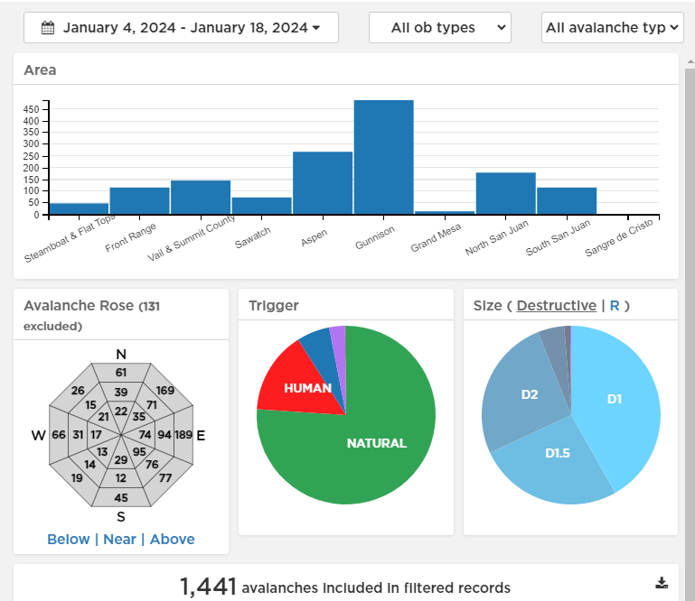
- The CAIC Avalanche Explorer shows 1441 avalanches reported between January 4 and 18. Of these, 32% are D2 or larger (large enough to bury, kill, or injure a person). Most reported avalanches occurred on east-facing slopes: 25% of all avalanches and 33% of the D2 or larger avalanches. Southeast and northeast followed closely behind. There is a much smaller fraction of total avalanches on other aspects, but we did see more avalanches occurring on all aspects than during a typical period.
- We have reports of 11 people caught in avalanches, with no full burials, 5 partial burials, and 3 injuries. Thankfully, there have not been any avalanche fatalities in Colorado so far this season. Avalanche safety is a community effort that involves good forecasts--which are supported by public observations--good education options, and people using all the tools at their disposal to make good decisions and stay safe in the backcountry.
We are not out of the woods yet. This storm cycle fell on a holiday weekend when there is always an increased risk of an accident. Because of the increased avalanche danger, rapidly changing conditions, and increased safety risk, CAIC issued a Special Avalanche Advisory, Avalanche Watch, or Avalanche Warning for 11 straight days during this storm cycle. When conditions are obviously scary, it’s easy to dial back our backcountry ambitions.
The avalanche danger as of January 22 is CONSIDERABLE (3 of 5) in many areas of Colorado. This means dangerous avalanche conditions. The week of January 22 will bring a slowly easing avalanche danger and tricky conditions. It’s more challenging to continue making conservative choices as the screaming signs decrease. Obvious signs of instability, such as recent avalanches, rumbling collapses (whumpfs), and deep shooting cracks, may become less prevalent. But the snowpack structure will see little change. A very weak layer of collapsible snow sits beneath a thick slab of snow that formed from our January storms. Although avalanches are getting harder to trigger, the average size of avalanches is unchanged, and may grow even larger as the slabs connect across more terrain features.
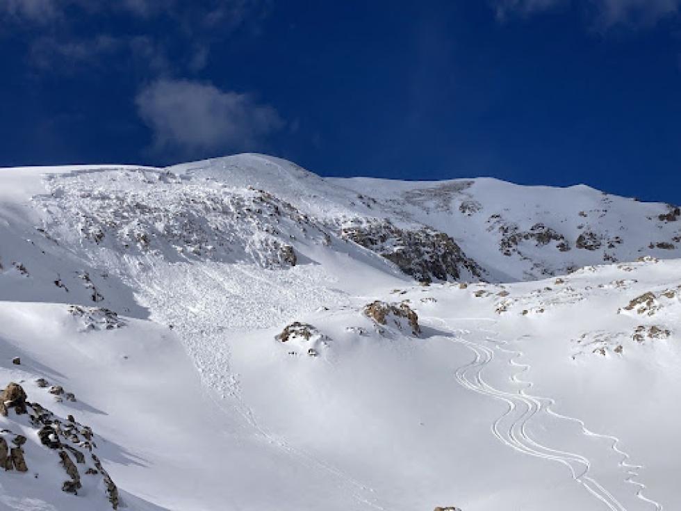
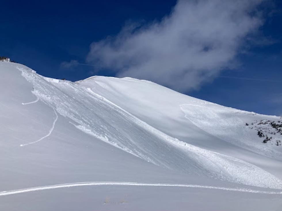
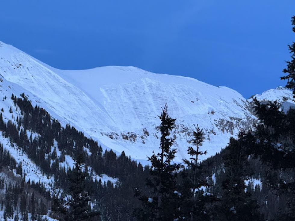
The three images to the right illustrate the widespread dangerous conditions across the state.