Weather Stations – Measuring Precipitation
By Nick Barlow
One of the most useful resources provided on the CAIC webpage is the weather stations page (Observations > Weather Stations). Here you will find a table of hourly and archived observations from a large network of weather stations throughout Colorado, sorted by forecast zone and elevation.
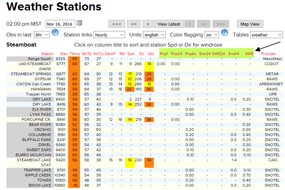
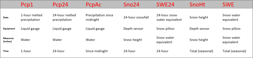
The several highlighted columns report different quantities of precipitation. For SNOTEL stations, up to seven different readings are given. Below is a description of these readings, the instruments that take them, and how the data can be useful for backcountry users.
Snow Water Equivalent (SWE)
SWE is the total amount of water contained in a fixed sample of snow. More simply, it is the resulting depth of water if the entire sample melted. In this context, “sample” could mean the entire seasonal snowpack (SWE), or just new snowfall over the past 24-hours from a single storm (SWE24). Seasonal SWE is particularly useful for long-term hydrological applications, such as forecasting water supply or seasonal runoff. For example, water managers use the data to determine how much water is stored in the mountain snowpack for the warmer months ahead. This is the primary function of the SNOTEL network, and the strategic placement of stations in important water basins throughout the United States. Yet SWE is also relevant for backcountry users.
The density of water varies only slightly with temperature. By contrast, snow density varies significantly from storm to storm. The SWE calculation is a way of standardizing snowfall for use in further applications. When we think about loading weak layers in the snowpack, calculating SWE can be of great value. The data can reveal the load added to the snowpack from an individual storm. By comparing SWE to snow depth, we can also discern whether the storm snow was dense and heavy vs. light and fluffy.
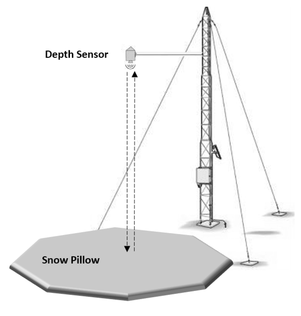
At SNOTEL stations, SWE is measured using snow pillows: large 3-meter x 3-meter bladders (steel and rubber) installed on the ground and filled with a volume of antifreeze. As snow accumulates on top of the pillow throughout the winter, instruments measure the increasing hydrostatic pressure upon the liquid. With that, the mass of the overlying snow is calculated. Knowing the density of water allows us to calculate SWE. A snow depth measurement allows us to calculate snow density.

Measuring Snow Depth
Snow depth is perhaps the easiest quantity to measure, simply by using a ruler or avalanche probe. It is more complicated at remote weather stations with the automated measurement and logging of data.
At SNOTEL stations, an ultrasonic depth sensor mounted above the snow pillow measures the snow depth. The sensor sends a signal downward towards the ground and measures how long it takes the signal to bounce off the snow surface and return to the sensor. Knowing how fast the signal travels, a properly-calibrated sensor will give an accurate reading of snow depth. On the weather station page, there is a field for changes in depth over a 24-hour period (Sno24), in addition to the total depth of the snowpack (SnoHt).
The ultrasonic sensor is also useful for backcountry users. Most simply, it is the only tool at a SNOTEL station that can tell you how much new powder you’ll find on any given day. However, you can glean more, and more important information from a SNOTEL site.
For one, the total depth of the snowpack can be particularly useful. A shallow snowpack can promote changes in snow structure, and create persistent weak layers. This is important information to gather before traveling into the backcountry. On a shorter time-scale, the amount the snow depth increases in a single storm is a good estimate of how much snow is available for wind transport. We can also estimate the depth of new Storm Slab or Wind Slab avalanches, and at what depth we might find the old/new snow interface in our snow pits.
Measuring Liquid Precipitation
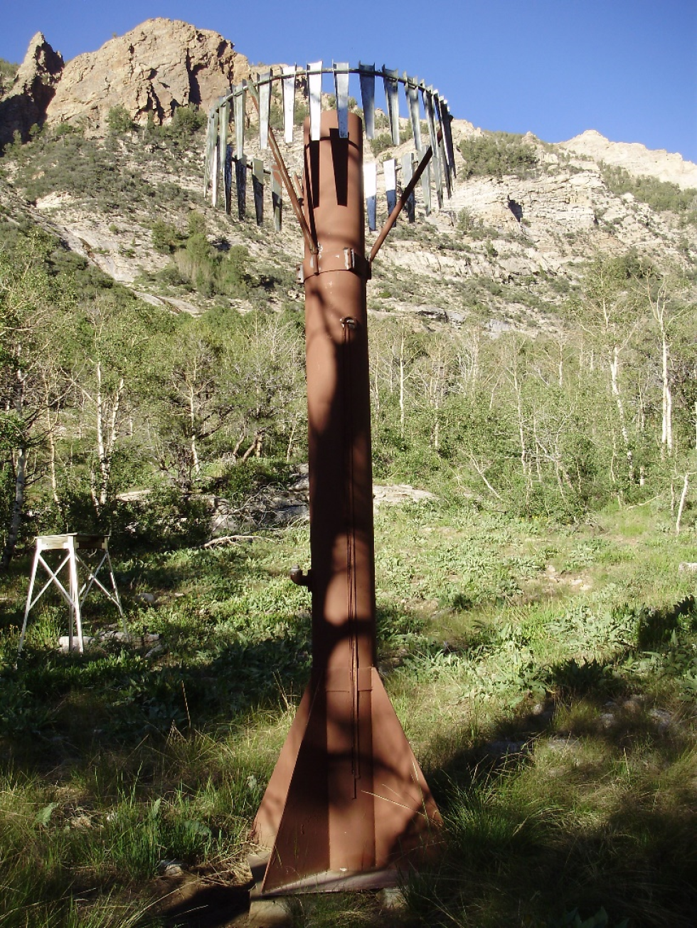
SNOTEL stations are equipped with a precipitation gauge to measure liquid for the entire water-year. During the warmer months, rain simply falls into the gauge. The gauge then measures and logs the data automatically. Snow also falls into the same gauge during the winter months. However, sub-freezing temperatures would make any kind of liquid measurement essentially impossible. To combat this effect, SNOTEL precipitation gauges are “charged” with a volume of propylene glycol, melting the snow on contact as it falls into the gauge. The gauges also contain mineral oil, designed to sit on top of the collected liquid and prevent evaporation over time. On the weather station page, data is in 1-hour (Pcp1), 24-hour (Pcp24), and since-midnight (PcpAc) format.
For backcountry users, liquid precipitation data can also be useful. Ideally, data from this gauge would match the calculated SWE data from the snow pillow and ultrasonic sensor. This is not always the case. It’s important to recognize the differences and primary functions of each piece of equipment. Data from the liquid gauge is used for seasonal purposes. The gauge keeps measuring precipitation long after the snow melts away from the snow pillow.
However, the data can be used in conjunction with the SWE and snow depth in order to provide a more well-rounded answer to what is going at the station. An example would be for rain-on-snow events.
Snow pillows may not always capture added SWE from rainfall, as some of the liquid may channel away from the pillow. In this case, the liquid gauge is the only piece of equipment that could tell us if rain-on-snow has occurred. A simultaneous temperature reading from the SNOTEL could also reinforce our suspicions.
Takeaway
Remember that automated SNOTEL stations exist in remote mountain locations. The stations use three different pieces of equipment to measure precipitation, and each piece has its own unique purpose for being there. Like any equipment, the gauges are prone to both random and systematic errors, and the data may not always be trustworthy.
A variety of issues can (and do) arise at SNOTEL stations. For this reason, they require continued maintenance and quality control of the data they output. This can be exceptionally difficult during the winter months, as access to many of the stations is difficult.
As backcountry users, we should analyze each piece of data individually before forming a conclusion about what has transpired. Compare the different forms of output (SWE, depth, melted liquid) and attempt to read between the lines.
Also, recognize the data is from a single point, and may not be representative of the entire area in which you’ll be traveling. Of all meteorological surface measurements, precipitation is by far the most spatially variable. You will likely find inconsistent snowfall results within different elevation bands and aspects as well. Study the data from other near-by stations; learn which stations typically receive more or less snowfall than others.
Most of all, be thankful the SNOTEL network exists. It is a wonderful tool to have at our disposal. These stations shed light into the dark and cold, providing us with vital information at just a mouse-click away.