Avalanche Danger as a Continuum
It is human nature to draw discrete boxes and categories around things. “That book is not science fiction,” “I’m a Mac person,” “Its just a class III rapid with big waves,” or “that’s a 5.11." Then we pick and poke at the borders when things do not quite fit. “McCarthy writes lit-fic,” “but I use Gmail,” “at low water it’s got a class IV- entry" or “no, it’s only a 10c."
Avalanche forecasters are no different. In our morning staff discussions, we will sometimes describe the danger to each other with phrases like “LOW side of MODERATE” or “on the cusp of HIGH.” It is like thinking of Avalanche Danger Ratings as a continuum instead of discrete boxes.
Partly that comes from the Avalanche Danger Scale itself. The five danger levels include multiple elements. There are five sections of travel advice describing how we think you should approach the snowpack. The Likelihood includes both triggered and spontaneous avalanches, and there are multiple combinations of expected Size and spatial Distribution. We can mix and match from the categories as necessary to arrive at a danger rating. That gives us many options to end up with a final danger that looks like a discrete category. For example, we can select a MODERATE (Level 2) danger when it is unlikely travelers will trigger an avalanche, but it will be very large (D3).
It might be worth visualizing the danger since late January. I’m going to generalize, but most of the forecast zones followed a similar pattern. At the end of the January dry spell, the avalanche danger was MODERATE (Level 2) near and above treeline. The problems were concentrated on just a few aspects.. The danger started to rise as snow accumulated, climbing quickly through CONSIDERABLE (Level 3) to HIGH (Level 4), where it remained during the Avalanche Warning.
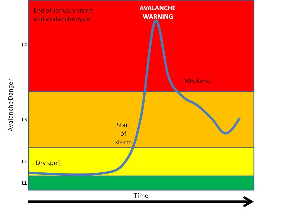
The danger fell into CONSIDERABLE (Level 3) the first few days in February. Wind events kept the danger at the upper end of CONSIDERABLE (Level 3), with natural avalanches possible as the winds drifted snow and overloaded some slopes. The danger eased slightly as the wind loading decreased. Starting February 3, modest amounts of snowfall provided additional loading and snow for transport. The snowfall was not sufficient to cause natural avalanching. Human triggered avalanches remained likely, well demonstrated by observers.
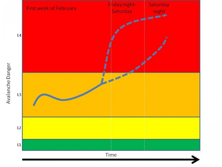
Another storm is on the horizon. Snowfall looks more impressive than the last few days, and it will come with winds. We are anticipating the avalanche danger to rise again. How quickly is the question–will it jump on Friday or Saturday night, and skyrocket or slowly build?