April 2024 Summary
Summary
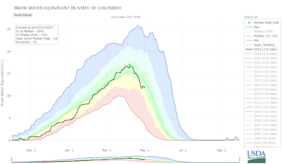
Following a snowy March that inched the statewide Snow Water Equivalent (SWE) above the 30-year median, April delivered a generous amount of warm, sunny weather bookended by snowy periods. There were three snowy periods during the month: April 6 to 8, April 15 to 16, and April 27 to 28. These small storms helped pump the brakes on an overall depleting statewide snowpack and an early start to the runoff season.
There were about 40% fewer reported avalanches in April than in March.
- 557 avalanches recorded across the state
- 50 avalanches size D2 or larger (85% less than March)
- One avalanche size D3 or D3.5 (95% less than March)
- 119 human-triggered avalanches (39% less than March)
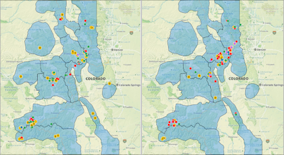
- 25 avalanche incidents and accidents (Northern Mountains – 18, Central Mountains – 3, Southern Mountains – 4)
Thankfully, we escaped April without a fatal avalanche accident. There were numerous close calls with multiple people caught and two incidents resulting in injuries—one of which involved a CAIC forecaster (click here for the full report).
Early April
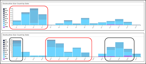
Following a snowy March, April quickly transitioned to more spring-like weather. The significant warm-up from April 1 to 5 introduced the first pulse of meltwater to a dry snowpack, and we observed the first statewide uptick in wet snow avalanches. Throughout the state, slopes with overlapping wet avalanche concerns and lingering persistent weak layers in the upper snowpack are where we saw the largest avalanches. The highest daily number of avalanches occurred on April 3 (81 recorded avalanches) following multiple days of warm daytime temperatures and nighttime lows below freezing.
April 6 to 8
Following the early April warm-up, the first of three storms brought a foot of snow to much of the Northern and Central Mountains, while the Southern Mountains received half as much. A strong cold front charged across the state, plummeting temperatures and refreezing the snowpack – effectively shelving wet snow problems for the time being. This storm shifted the primary avalanche concern back to new snow and drifting hazards, while deeper weak layers became more stubborn to natural and human triggers.
In the Southern Mountains, we removed the Persistent Slab avalanche problem from parts of the region. This snowpack transition gradually progressed from south to north in the state. By April 11, we removed the Persistent Slab avalanche problem in areas except portions of the Central Mountains where it was listed as unlikely.
April 13 to 15
By mid-April, the spring weather-coaster was in full effect. This period marked the first prolonged window of non-freezing nighttime temperatures in the Southern Mountains, and weak, shallow freezes across the Northern and Central Mountains. Loose Wet avalanches moved to the forefront for many places, and Wet Slab avalanches became a growing concern in the Central and Southern Mountains where meltwater pushed deeper into the snowpack. Still, avalanche activity underperformed expectations. Following the next sharp cool-down, the Persistent Slab avalanche problem that plagued the state since November was removed from all regions by April 15.
April 15-20
This stormy period contributed to the strongest north-to-south gradient in snowfall. The Front Range Mountains were the breadwinner with snowfall totals ranging from 1 to 3 feet. Further south and west of the Continental Divide, snowfall totals were much more sporadic and meager. Once again, the primary avalanche hazard was driven by new snow and drifting. We observed one of the two largest single-day increases in reported avalanches for this season between April 15 (1 reported avalanche) and April 16 (27 reported avalanches).
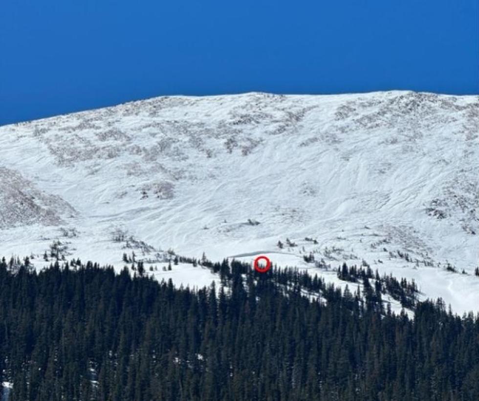
In the ensuing days, avalanche activity reduced significantly. By April 18, LOW (1of5) danger blanketed Colorado with generally safe avalanche conditions continued through a period of quiet weather. The combination of sunny skies and consecutive days of lower avalanche danger set the stage for an avalanche incident in Rocky Mountain National Park that involved a group of seven. This incident occurred in the Dead Elk Couloir on April 20 and involved multiple groups traveling in close proximity (click here for the field report).
April 20-May
The warmest period of the month occurred from April 20 to 25 and was more impactful across the Northern Mountains where the spring transition had been slower to evolve. Despite freezing levels pushing as high in elevation as we have seen this spring, the avalanche danger peak was modest. The wet snow hazard followed a standard spring pattern of more dangerous near and below treeline from deeper snowpack wetting.
This last snowy period was tough for weather models to nail down. Despite the failed hype of a mega-storm, it still delivered a solid up-slope event for the Front Range Mountains. In the end, the more southerly track benefited more mountain regions – 1 to 2 feet of denser snow to the Northern Mountains and around a foot across the Central and Southern Mountains. We received reports of 8 avalanche-related incidents from April 27 to 29.
Looking Ahead
Throughout April, the primary avalanche concerns evolved from the long-standing Persistent Slab avalanche to a hodgepodge of wet snow and new snow hazards. This enabled more people to step out into bigger and more complex terrain with confidence. However, this is probably why we saw frequent spikes in reported avalanches each time it snowed. The places where we observed the highest density of avalanche-related incidents in April are the same places that received the most snow and the slowest to transition to more spring conditions.
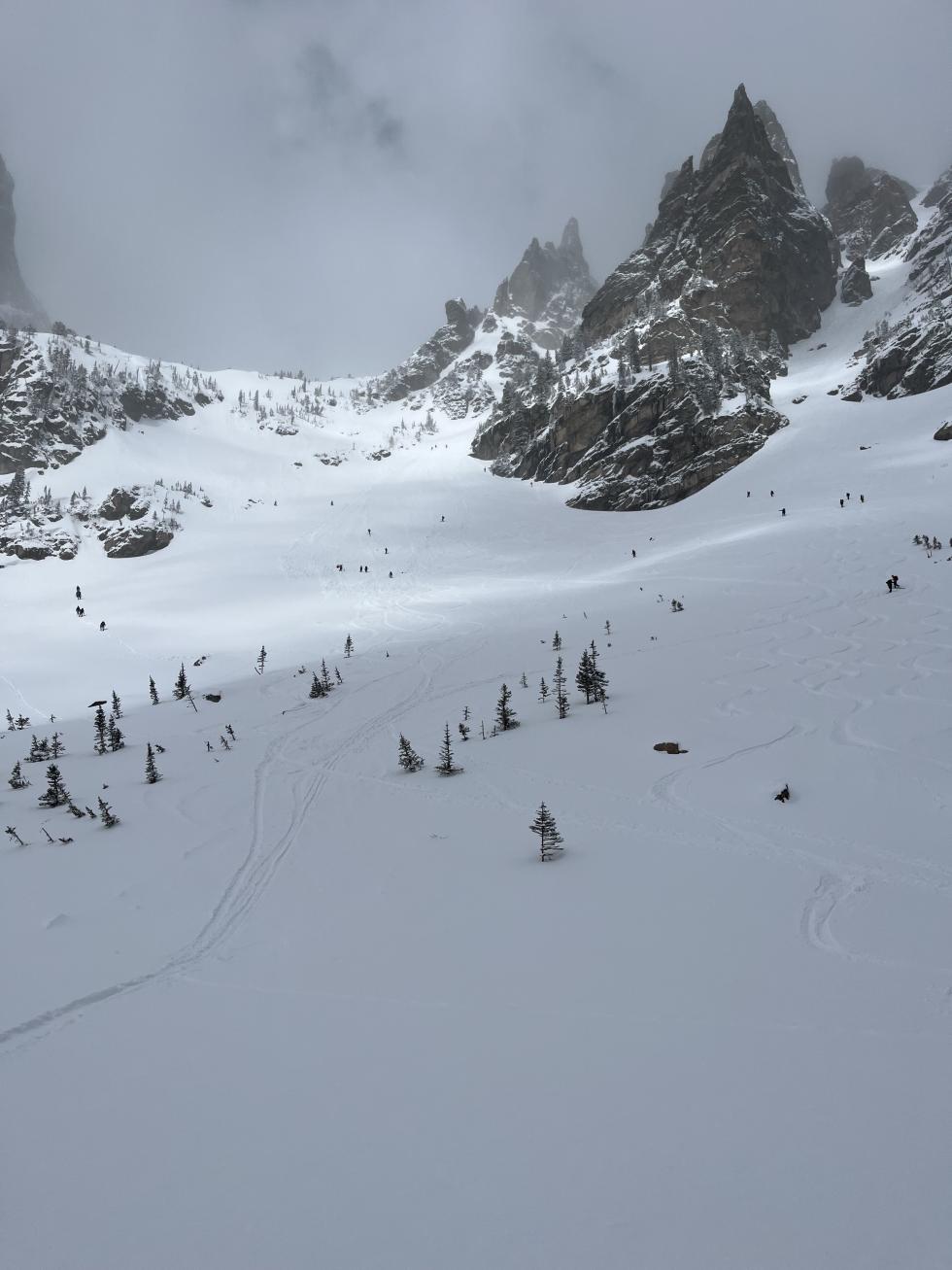
Spring adventures offer an excellent opportunity to get into terrain that’s only fathomable mid-winter, but avalanche hazards will exist as long as slopes are snow-covered – even if smaller in size and scope. Continue to use proper backcountry travel protocols, carry avalanche rescue gear, and don’t jump the gun and get in trouble.