Check out the New Features on Our Website
Updated Weather Forecast Features
The Colorado Avalanche Information Center provides both weather and avalanche forecasts for the Colorado mountains. Weather events create avalanche conditions, making the weather forecast essential to understanding avalanche forecasts and conditions. Great news: We’ve updated our homepage weather forecast display with new features and functionality as well as updated the functionality on our weather forecast page!
How to access the weather forecast:
- From the homepage: When you click a location on our homepage map, a side panel opens with three tabs: avalanche forecast, forecast discussion, and weather forecast for that location. Go to the weather forecast tab.
- From the weather forecast page: Access the "Weather Forecast" page under the Weather menu.
What’s new?
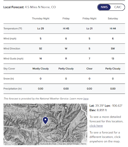
Homepage Weather Forecast: The weather forecast tab now includes a table for four 12-hour periods to match our avalanche forecast. The weather forecast shown in the table is for the exact location you selected on the homepage map. This location is shown on the inset map with the latitude, longitude, and elevation of the forecast. To update the forecast location (e.g., move it up a drainage or across a few basins), you can select a new point on the main or inset map. By default, table values are from the National Weather Service. You can also select “CAIC” to view the WRF 2km output using the toggle at the top of the table. For those of you who geek out on weather, you will also be able to see all the details of CAIC’s weather model – hourly values in graphs – for the next 84hrs. Pro tip: If you have specific locations you check regularly, bookmark that spot to have consistent forecast elevations.
Weather Forecast Page: We publish a weather summary on this page by 6am and by 1pm daily. Now, instead of finding weather forecasts for 21 set points, this page has a map with a click-for-a-point forecast.
Accident Explorer
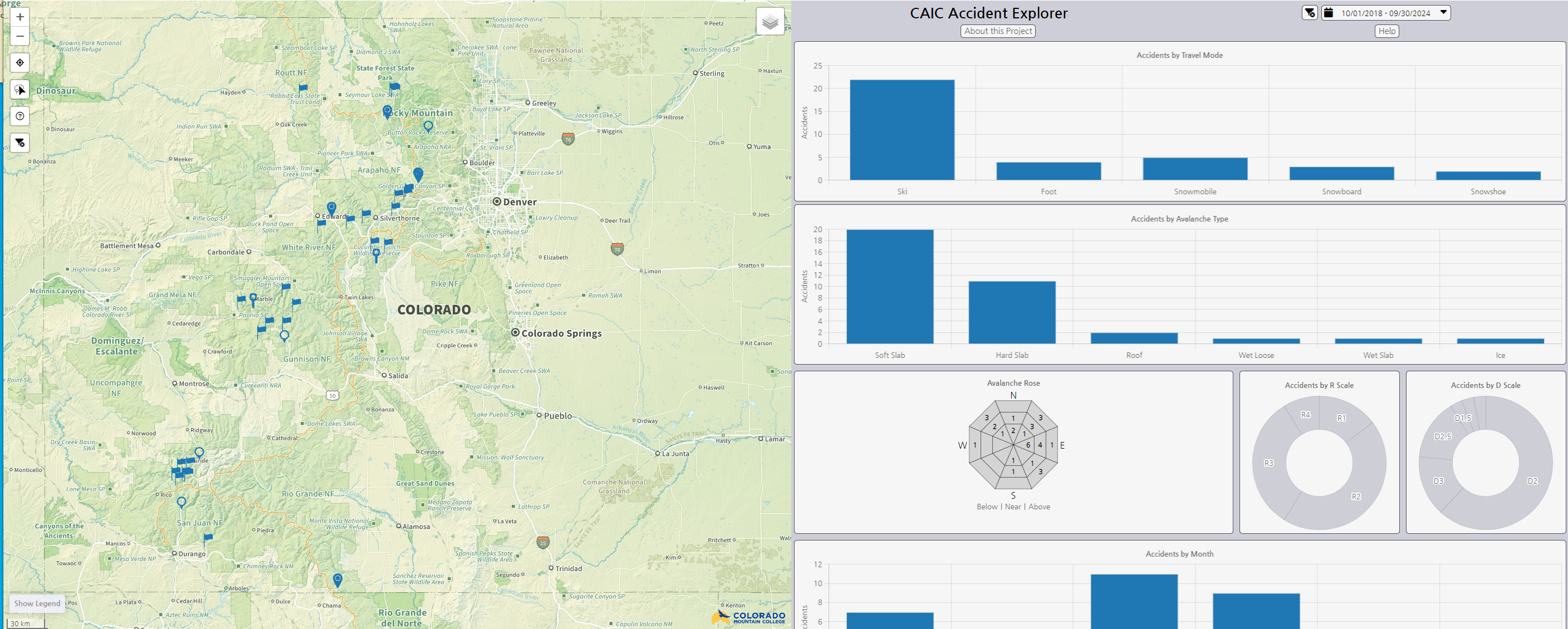
We partnered with Colorado Mountain College’s (CMC) Geographic Information Systems (GIS) program to develop the Avalanche Accident Explorer: an interactive map that displays information about Colorado’s fatal accidents since December 2009. Dara Seidl, CMC Leadville’s Associate Professor of Geographic Information Systems, and CMC students Lucy Kepner and Joe Tayabji created the geospatial visualization tool to help people more easily explore fatal involvements with avalanches.
How to use it?
The Avalanche Accident Explorer is accessible from the CAIC website under the Accidents menu. The Accident Explorer includes an interactive map on the left and a series of connected charts on the right (below the map on small screens). The page will start with accidents within the last five avalanche years (October 1 through September 30). You can change the date range at the top of the chart panel. You can filter the accident records by clicking on the charts. You can select accidents from a specific area with the lasso tool on the map. Learn more about using this tool here. For more information about the data, go to CAIC Statistics & Reporting.
What’s Next?
Currently, only fatal accidents where at least one death occurred are depicted in the map. CAIC and CMC plan to incorporate non-fatal accidents reported to CAIC in a future release.